Saturday, October 17, 2020

New Bedford Online (?) Summer 2020

UPDATE: Summer 2021 Online Field Course

We did not attempt to offer this course in the very uncertain summer of 2020. But we are making plans to offer it for undergraduate or graduate credit in Summer 2021. We have envisioned this as an entirely in-person class in the past, but we will be prepared to offer it partly or fully online in Summer 2021. 

We invite in-service teachers in particular to have a conversation about how best to organize this course for what will remain uncertain times for teaching and learning.

Saturday, March 30, 2019

Study Tour is a Verb

When we decided to offer a hands-on course about the geography of New Bedford for a second time, we considered reasons that it did not garner sufficient enrollment in previous years. Among them, we decided, was the choice of course number. As an experimental course, we had thought that the GEOG 400 Special Topics course was appropriate, but we decided that its high number might be off-putting, as it suggests prior coursework in geography. As we considered numbering at a more appropriate level, it occurred to us that GEOG 296 might be both more inviting and more descriptive. The course we envision is, after all, a sort of domestic study tour.
Although most of this course will take place on land, much of my own learning about New Bedford takes place on the water as an active member of both Whaling City Rowing and the Azorean Maritime Heritage Society.
(Rowing with WCR in this May 2018 photo, I am the one in the pink hat.)
How This is Different from Most Study Tours

The term "study tour" usually describes short-term experiences in other countries. At Bridgewater State University, these are typically 10 to 20 days in length, led by a faculty member. The New Bedford Maritime City course is a similar length, but it does not involve airplanes, passports, or overnight stays. 

The course does begin and end each day at the New Bedford municipal airport, but only because this is a convenient location for BSU-arranged parking.

How This is Similar to Other Study Tours

Most of my study-tour experience has been in Nicaragua, where I have led (with the incredible assistance of local guides) 11 study tours and one non-credit tour. Well over 100 people have enjoyed this experience, many of them returning either with me or on their own. In the process of leading this course -- plus one in Cabo Verde -- I have decided that I really like this format and I know how to make it both an effective and enjoyable learning experience.
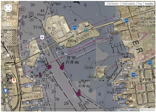
Detail of New Bedford harbor nautical chart,
with satellite overlay. The professor spends a lot of time
in the center of this image!
The characteristics of a study tour (aka travel course) that will be part of the New Bedford course include:
  • Most learning will be through activities, rather than extensive reading.
  • Those activities will be carefully planned and chosen, so that both the professor and the students are learning from local experts.
  • The experience is self-contained, so that no particular coursework is required as a prerequisite. In fact, students bringing a variety disciplinary backgrounds to the course enrich the experience for all.
  • There will be a fee beyond tuition, though in this course it is much less than in a travel course. The fee covers admission to some facilities and some snacks.
  • The entire group travels together in a van for each day's activities.
  • Students keep a journal of their experience, and write a reflection paper at the end of the course. 

Graduate-Credit Note
This course is also listed as GEOG 520, so that in-service teachers or others seeking graduate credits can benefit from the experience. Such participants will complete all of the activities required of undergraduates, plus a research or curriculum project that will help them to meet professional goals. These projects will be agreed upon in individual consultation with me prior to the start of the course.

Friday, March 15, 2019

Why Teach New Bedford?

Shortest answer: The city will teach itself.

By this I mean that for geographers, a place is a text and geographic learning occurs by approaching that text with curiosity and humility. For the summer course I am offering in New Bedford, I will serve simply as an example of a geography learner and as a bridge to this fascinating city.

We will not, however, simply be wandering around asking questions -- although we will be doing some of that (known professionally as "walking tours" and "windshield surveys"). Rather, we will visit one or two of the city's institutions each day, with specific questions in mind. I have the great fortune of being a member of several associations in the city, and of having friends and acquaintances in quite a few of its companies, departments, and organizations.

These connections will be our real bridges to Whaling City!

The New Bedford-Fairhaven Bridge will be both a tangible part of the course -- I pass over it and under it several times a week -- and a metaphor for my approach to the bridge. The anchor is just a bonus. I took the photo on Pi Day 2018 from the front of Fathoms, one of many local restaurants that thrives on New Bedford's globally important seafood industry.
But What About Why?

All of the forgoing sidesteps the question that opens this post: why teach about New Bedford?

I have thought about this for years, of course, but more intensely since a brief conversation with a fellow whaleboat rower yesterday morning. Returning to the marina as the dawn broke over New Bedford (rowers are extreme morning people), we were admiring the view of the gleaming waterfront.

She mentioned a photo that she has on her office computer, showing a scene much like that we were looking at, but in even more dramatic light. A coworker asked her if it was of San Diego and she replied that no, it was New Bedford. He was dismissive, despite the photographic evidence and despite the fact that he is from Lowell, another of Massachusetts' underrated gateway cities. These are the cities that house 1 in 7 Massachusetts residents and a slightly higher proportion of its employment. They do have lower income and higher crime rates than the state average, but the pathologies of gateway cities are exaggerated in the lens of television news, and people from both smaller towns and larger cities tend to miss much of what the "second-tier" population centers have to offer.
I took this 5:30am photo of the New Bedford waterfront from Pope's Island Marina, in the first few minutes of summer, 2016. It was this or a very similar photo that garnered a surprised reaction from my fellow rower's officemate. And views like this remind me of the loan officer in nearby Bridgewater who told me New Bedford is not near the water.
I have found it very rewarding to explore the city of Brockton with a several first-year seminar classes, and will be doing so again in the fall of 2019. When I learned of the chance to offer a summer course over a two-week series of extended afternoon sessions, it took me about two minutes to decide that an exploration of Whaling City was in order.

Who is my target audience? Simply: everyone.. This is a 200-level class open to all, but I can also offer it as a 500-level graduate course by tailoring extra assignments to the needs of individual students. I hope that this will include classroom teachers from gateway cities and small towns alike. I hope to have at least a few people who already know New Bedford well (they will gain from the geographic perspective) and some who arrive with little real knowledge of the city. I look forward to bringing all such learners around to the remarkable constellation of contacts we have cultivated in this Maritime City.

Much more about this city from my point of view can be found on this blog; details about registration are at BSU Summer.


Wednesday, February 13, 2019

New Bedford: America's Maritime City

New Bedford Fortnight will be on the BSU Summer schedule in 2019 under a new name: America's Maritime City (registration opens March 11). We realized that the theme of the course might make for a better title than the length of the course -- especially since "fortnight" is a term that has become rather too obscure. The idea remains the same, however: spend two weeks exploring the geography of a most remarkable city!

Azorean whaleboats were featured in
National Geographic
GEOG 296 is a local study tour that will meet every weekday afternoon for two weeks, June 3 to June 14, 2019. Class will begin and end at a local parking lot, so that I can take students by van to each day's destinations. Meeting for four hours each day, we will have time for guided tours and lectures at many of the city's leading institutions. We will also have time for walking tours in some of its most fascinating neighborhoods. 

Most classes will run 12:30 to 4:30 pm. The exception will be Thursday, June 13, when we meet 3:00 to 7:00 pm to participate in New Bedford's famous AHA! Night a monthly festival that is an important factor in the revitalization of the city.

GEOG 296 is a 3-credit course that is available to any BSU student. Credits transfer easily, so students from other universities -- including students who are back home for the summer from schools elsewhere. Because of the variety of perspectives that will be included in this course, it will have something to offer students from other places as well as lifelong New Bedford residents. 

The course is also available as GEOG 520 to students -- including in-service teachers -- seeking graduate credit. Extra research or lesson planning will be required, and will be tailored to individual students.

The central theme of the course is the way New Bedford has been able to harness its historic and cultural heritage to promote its economic and social development. We will learn about New Bedford from the point of view of languages, food, and music as well as whaling, fishing, and manufacturing. We will also explore its important place in African American history and the geography of immigration. We also have some excellent opportunities to explore New Bedford's physical and environmental geography, and to get out on the water.

Where's Hayes-Boh? Although your professor has sailed on the boat shown in this article, he is not in the photo. He is, however, in the photo used as the overall blog banner at the top of the screen. Can you spot him?

Friday, December 15, 2017

Harbor Forecasts

As I write this, the screenshot below reflects current conditions in New Bedford Harbor, as reported on the very useful web site U.S. Harbors, which provides similar information -- and much more -- for coastal communities throughout the United States. For each port, the site assembles real-time data with general ten-day forecasts and hourly, detailed 48-hour forecasts.
In our New Bedford Fortnight course, we will learn a lot about the geographies of the historic whaling trade, including the biogeography of whales, the migration patterns of those who pursued them, and the influence of the whale trade on the economic geography, urban landscape and demography of New Bedford.

We will also learn about some aspects of the physical geography of New Bedford through the lens of the whaleboat hobby and sport that is increasingly popular in the city. In fact, much of what I know about the city has been learned in modern replicas of the historic Azorean and Yankee whaleboats, as I am an active member of both of the city's clubs - the Azorean Maritime Heritage Society and Whaling City Rowing. I also learn from occasional involvement with the Buzzard's Bay Rowing Club in nearby Fairhaven, whose members row on the same waters. All three clubs interact frequently with the city's Whaling Museum, of which I am also a member.

Members of all three clubs consult weather and tide charts to plan routine rowing events and special events including races and excursions. Rowing within the dynamic harbor environment requires planning routes according to wind and tide, as well as seasonal variation in the traffic of commercial ships and pleasure craft. Rowing captains consider the experience of crews and expected wind speeed when determining the safety of a planned row; individual rowers will consult the forecast when planning what to wear, especially during the colder months.
Our summer course will include some whaleboat demonstrations, but there will be no snow on the oars, as in this photo of pre-dawn rowing on December 14, 2018. Photo credit: Cyn Spence. I am the rower in the striped shirt.
Lagniappe

My main blog -- Environmental Geography -- includes three relevant articles from the early days of my harbor learning in 2012. The first -- Harbor Learning -- describes the use of weather forecasts in a bit more detail. Rowing and Rocket Science explains how some of us use geotechnologies during the rowing itself, and the convergence of many technologies that we have come to take for granted in smartphones. More broadly, Seaside Changes points to some reporting that was then being done on the changing geographies of New Bedford and many similar cities in New England -- changes that are the inspiration for this special summer course.

Tuesday, November 21, 2017

A Avenida

Acushnet is the name of a rural town just to the east and north of New Bedford. It is also the name of an avenue, often known simply as "The Avenue." That would be "A Avenida" in Portuguese, the most prominent of several languages one can hear in this vibrant neighborhood -- perhaps the most diverse locale in one of the most diverse cities in the most diverse country on the planet. In other words, a must-visit place for geographers.

So on August 29, 2017, I decided to take a bit of a stroll, to explore a half-mile or so of a street that I had mainly viewed from my car windows. (NOT that there is anything wrong with that -- geographers can learn a lot from a "windshield survey," which is our professional name for "driving around.")

Here is some of what I found.

Calling Acushnet Avenue "The Ave" is not just something my local friends say. It is a recognized place, and people are proud of it.
The role of the arts -- especially public art such as this mural -- in social and economic development will be a central theme of the course.
The outward-facing parts of homes and businesses comprise what geographers call the vernacular landscape, and at times they can provide insight into what people consider most important about their own identities.
To prepare for a special occasion, one does not go to the mall.
I have not yet been to this café, but it is now on my list -- the Sunflower Cafe. In the Germanic languages, the flower is named for the sun. In the Romance languages, it is named for turning with the sun.
Some of the most successful businesses in Central America are fried-chicken restaurants, some of which have expanded to migrant communities in the United States. I have not yet figured out whether the connection in this case is one of ownership or one of symbolic reference.
Although its Lusophone connections are best known, Central American and other parts of the world are well represented in New Bedford's neighborhoods. 
In many ways, communities are defined in very local institutions such as hairdressers and barbershops.
This city of migrants is full of symbolism that exhibits pride in places of origin and places of destination alike, as on this sign marking the approach to Madeira Field.
A friend who grew up in another part of the city ALWAYS brings something from this case if she is coming to dinner at our house.

This one is a bit of a trick -- it is not on Acushnet Avenue, nor is it in New Bedford. This is White Factory, on the Acushnet River in Acushnet, less than a mile from the eponymous Avenue. 
Students in the New Bedford Fortnight class will have opportunities to find much more in this and other neighborhoods throughout the 24 square miles of the Whaling City.


Saturday, October 21, 2017

Learning from Old Maps

Image: Knowol, which sells prints of this map
and hosts many other fascinating maps and images
Click to enlarge
During the New Bedford Fortnight class, we will spend most of our time in direct experience of the present-day city, its cultural landscape, communities, and institutions. It is a city with a rich history, however, and we will be studying that from a geographic perspective.

Among my favorite tools for this kind of work are very detailed Sanborn fire insurance maps, which we will be looking at in some detail, both at the New Bedford Public Library and through the digital version to which BSU's Maxwell Library subscribes. 

I learned of the 1871 map shown above from a friend who has spent his whole life (so far) in the city and who will be part of this course. The map is stylistically similar to the Sanborn maps, but it is at a smaller scale that will be useful for our initial look at historic changes in the city and in adjacent areas of Fairhaven. The bridge connecting the two, for example, does not follow its current trajectory, nor does a broad boulevard separate downtown New Bedford from its working waterfront.